


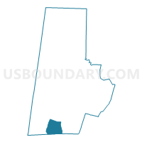
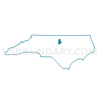
Voting District 35, Durham County, North Carolina
About
Outline

Summary
| Unique Area Identifier | 639929 |
| Name | Voting District 35 |
| County | Durham County |
| State | North Carolina |
| Area (square miles) | 7.40 |
| Land Area (square miles) | 7.28 |
| Water Area (square miles) | 0.11 |
| % of Land Area | 98.49 |
| % of Water Area | 1.51 |
| Latitude of the Internal Point | 35.88741970 |
| Longtitude of the Internal Point | -78.91991590 |
Maps

Graphs
Select a template below for downloading or customizing gragh for Voting District 35, Durham County, North Carolina


Neighbors
Neighoring Voting District (by Name) Neighboring Voting District on the Map
- Voting District 16, Durham County, NC
- Voting District 20-02, Wake County, NC
- Voting District 33, Durham County, NC
- Voting District 53-1, Durham County, NC
- Voting District 53-2, Durham County, NC
- Voting District 54, Durham County, NC
- Voting District 75, Chatham County, NC
Top 10 Neighboring County Subdivision (by Population) Neighboring County Subdivision on the Map
- Triangle township, Durham County, NC (93,373)
- White Oak township, Wake County, NC (72,894)
- Williams township, Chatham County, NC (13,624)
Top 10 Neighboring Place (by Population) Neighboring Place on the Map
Top 10 Neighboring Unified School District (by Population) Neighboring Unified School District on the Map
- Wake County Schools, NC (900,993)
- Durham Public Schools, NC (267,587)
- Chatham County Schools, NC (63,505)
Top 10 Neighboring State Legislative District Lower Chamber (by Population) Neighboring State Legislative District Lower Chamber on the Map
- State House District 41, NC (129,780)
- State House District 31, NC (91,274)
- State House District 54, NC (83,728)
- State House District 29, NC (70,046)
Top 10 Neighboring State Legislative District Upper Chamber (by Population) Neighboring State Legislative District Upper Chamber on the Map
- State Senate District 16, NC (220,672)
- State Senate District 18, NC (207,334)
- State Senate District 20, NC (181,624)
Top 10 Neighboring 111th Congressional District (by Population) Neighboring 111th Congressional District on the Map
Top 10 Neighboring Census Tract (by Population) Neighboring Census Tract on the Map
- Census Tract 20.27, Durham County, NC (7,272)
- Census Tract 20.20, Durham County, NC (5,894)
- Census Tract 536.01, Wake County, NC (5,351)
- Census Tract 536.02, Wake County, NC (5,009)
- Census Tract 207.01, Chatham County, NC (4,910)
- Census Tract 20.13, Durham County, NC (4,481)
- Census Tract 20.21, Durham County, NC (4,432)
- Census Tract 20.22, Durham County, NC (4,307)
- Census Tract 20.23, Durham County, NC (2,808)